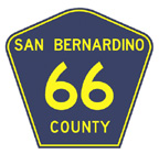
San Bernardino County in California plans to designate a portion of historic Route 66 as “County Highway 66” as a way to kick-start its County Route Marker Program.
According to a news release from the county:
Vice-Chairman Mitzelfelt is using $45,000 of his office’s discretionary funding to pay for the signage on the route. No federal dollars or other funding sources will be tapped for this effort.
More than 250 miles of this iconic highway run the length of San Bernardino County from Upland through Needles, making a portion of Route 66 by far the most appropriate place to launch the County Route Marker Program, the first to be added in the state since 1983.
Signs placed at various intervals along the route will serve as “bread crumbs” for travelers to follow as they explore significant landmarks.County Route 66 will begin on National Trails Highway in the unincorporated community of Oro Grande at the border of the City of Victorville, continue north onto Main Street in the City of Barstow, continue east on Interstate 40, travel north on Nebo Street near Barstow, head east on National Trails Highway, and then north on Goffs Road to its junction with US-95. Cultural and historical sites along this alignment include the City of Barstow and the communities of Daggett, Newberry Springs, Ludlow, Amboy, Cadiz, Chambless, Essex, and Goffs, as well as the Mojave National Preserve. This alignment can be expanded to include additional portions of or all of Route 66 at a later date.
According to Google Maps, using as much as old Route 66 as possible, the county will sign about 160 miles of Route 66. Considering how much of that stretch is desolate, more signs is a good thing for novice Route 66 travelers.
(Via Victorville Daily Press; image courtesy of San Bernardino County)

Way down at the bottom the press release mentions the letters of endorsement from the California Route 66 Museum and the California Historic Route 66 Association. The Association has applied for a grant with the Byways program to have the area between Needles and Barstow declared a Scenic Byway.
as a 50 year resident of the desert, i was stunned to learn that this portion of route 66, aka the mother road, aka the old national trail road, was not in the state or national register as a scenic road, esp since amboy crater is a national natural landmark. thank goodness, the county has taken the appropriate action to correct this oversight. can we assume that this county designation is the first step in that designation process?