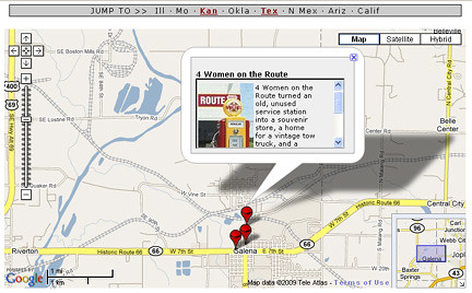
Drew Knowles, author of the “Route 66 Adventure Handbook” and the “Route 66 Quick Reference Encyclopedia” and proprietor of the Route 66 University site, has launched the interactive and open-source GPS 66 site.
He described it “as the closest thing yet to an online tour of Route 66, including precise GPS-based mapping, eyewitness commentary, and hundreds of photographs.”
Plenty of global-positioning system sites are out there tailored specifically for Route 66 travel. However, Knowles’ site aims to be more multimedia.
GPS 66 isn’t yet complete, but Kansas and Texas are finished. Knowles said in an e-mail that Missouri would be finished by the end of May. It’s hoped that Oklahoma and perhaps New Mexico would be finished by summer. He’s encouraging input and information from fellow roadies for the project to help make it more informative and fun.

The maps are nicely interactive. If you click on a certain town, the map enlarges and more interactive links will reveal themselves. Clicking on button will reveal information about a Route 66 attraction and sometimes a photo. A screen shot of the link to 4 Women on the Route in Galena, Kan., is shown above.
If you want to help with the project, go here.
I am very enjoy your blog, your blog is very true of the bar, hoping to see you more exciting content! I wish you have a happy day!